001 Adirondack High Peaks: Exploring The Mountain Wilderness
In northeastern New York, mountains rise above deep forests, cold streams, narrow valleys, glacial lakes, exposed rock, and some of the wildest country in the eastern United States.
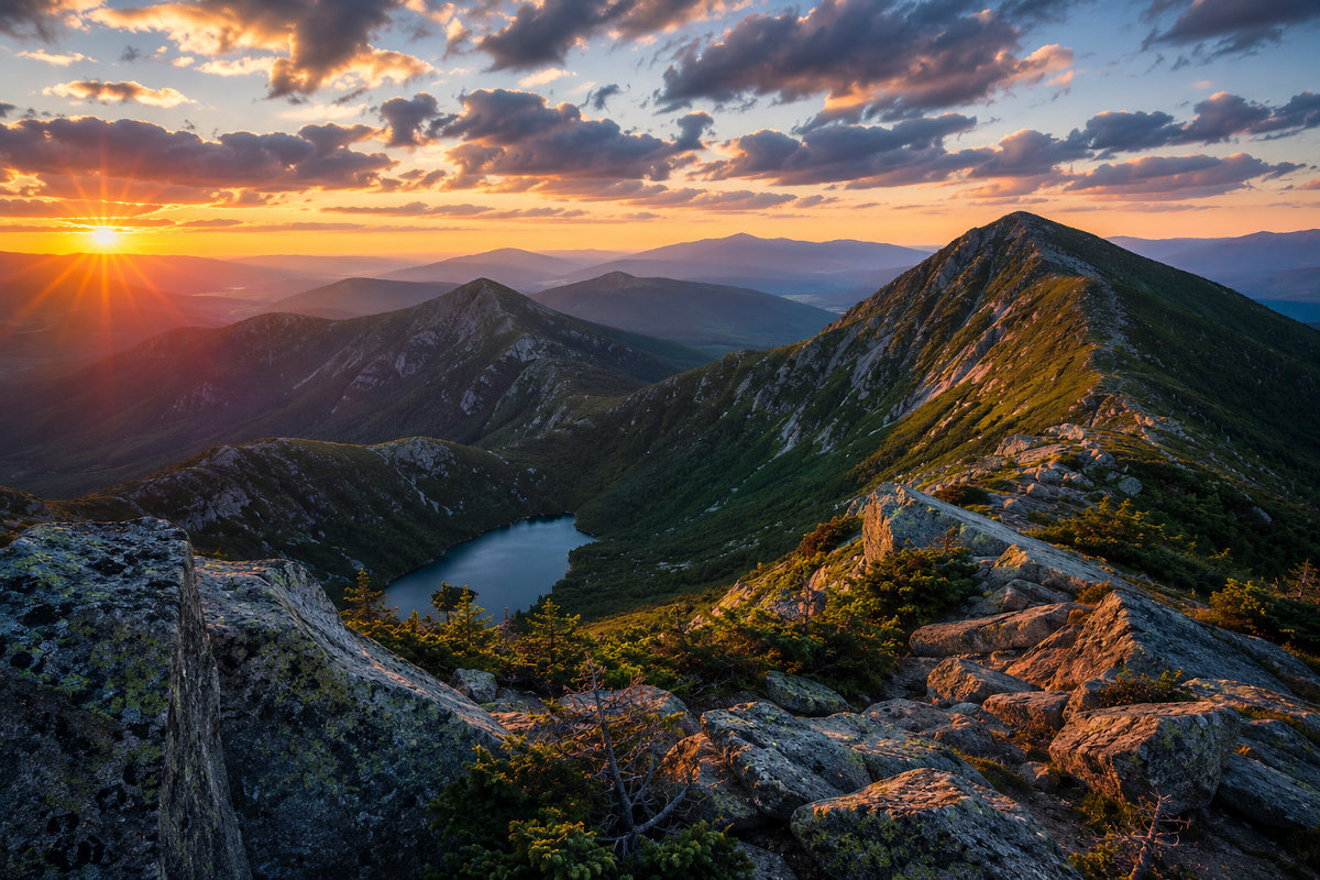
New York State Adirondacks High Peaks Offer Endless Scenic Views!
This is the Adirondack High Peaks—a landscape of dramatic summits, long ridgelines, alpine plants, historic trails, remote ponds, wilderness camps, and weather that can change without warning.
The region contains Mount Marcy, the highest point in New York State, along with Algonquin Peak, Haystack Mountain, Gothics, Whiteface Mountain, Giant Mountain, Cascade Mountain, and many other recognizable summits.
Yet the High Peaks is much more than a list of mountains waiting to be climbed.
It is a place shaped by ancient rock, rising land, glaciers, water, wind, forest, wildlife, conservation, and generations of people who have explored and protected the Adirondacks.
Some visitors come to complete all 46 traditional High Peaks. Others hike to a single overlook, walk around a mountain lake, study wildflowers, photograph autumn color, listen for birds, or simply experience the scale and quiet of the wilderness.
The High Peaks rewards ambition, but it also rewards patience. You do not need to reach a summit to discover the mountains.
What Are the Adirondack High Peaks?
The term Adirondack High Peaks generally refers to the highest mountains in the Adirondack region, especially the traditional group of 46 summits once believed to rise at least 4,000 feet above sea level.
Most of these mountains are concentrated in and around the High Peaks Wilderness of Essex County, near communities such as Lake Placid, Keene, Keene Valley, Wilmington, and North Elba.
The High Peaks Wilderness is the largest designated wilderness area in New York State. Together with neighboring state lands, private preserves, communities, roads, farms, and waterways, it forms the mountainous heart of the Adirondack Park.
Unlike a national park owned entirely by the federal government, the Adirondack Park contains a complex mixture of public and private land. Villages, homes, businesses, working forests, farms, wilderness areas, and protected waterways all exist within the park’s boundary.
This combination makes the Adirondacks not just a protected landscape, but a place where people and wilderness have developed side by side.
The Traditional 46 High Peaks
The Adirondack 46 High Peaks became famous through early surveys, guidebooks, maps, and the efforts of hikers who set out to climb every mountain believed to exceed 4,000 feet.
The traditional list includes:
- Mount Marcy
- Algonquin Peak
- Mount Haystack
- Mount Skylight
- Whiteface Mountain
- Dix Mountain
- Gray Peak
- Iroquois Peak
- Basin Mountain
- Gothics
- Mount Colden
- Giant Mountain
- Nippletop
- Santanoni Peak
- Mount Redfield
- Wright Peak
- Saddleback Mountain
- Panther Peak
- Tabletop Mountain
- Rocky Peak Ridge
- Macomb Mountain
- Armstrong Mountain
- Hough Peak
- Seward Mountain
- Mount Marshall
- Allen Mountain
- Big Slide Mountain
- Esther Mountain
- Upper Wolf Jaw Mountain
- Lower Wolf Jaw Mountain
- Street Mountain
- Phelps Mountain
- Donaldson Mountain
- Seymour Mountain
- Sawteeth
- Cascade Mountain
- South Dix, now widely known as Carson Peak
- Porter Mountain
- Mount Colvin
- Emmons Mountain
- Dial Mountain
- Grace Peak
- Blake Peak
- Cliff Mountain
- Nye Mountain
- Couchsachraga Peak
Later measurements revealed that several traditional High Peaks are slightly below 4,000 feet, while MacNaughton Mountain reaches approximately that elevation but was not included on the original list.
The traditional group remains unchanged because it represents more than modern measurements. It has become part of Adirondack history and hiking culture.
The Adirondack Forty-Sixers
People who climb all 46 traditional High Peaks may apply for recognition through the Adirondack Forty-Sixers.
The organization traces its beginnings to hikers Robert and George Marshall and their guide, Herbert Clark, who completed the 46 mountains during the early twentieth century.
Completing the list became known as becoming a 46er.
For many hikers, the goal requires years of planning, training, repeated visits, difficult weather, navigation, long drives, early mornings, and lessons learned through experience.
Some summits can be reached by well-marked trails. Others require long approaches, herd paths, route finding, stream crossings, steep rock, mud, snow, or winter conditions.
The challenge is not simply reaching 46 high points. It is learning how to travel responsibly and safely through a demanding mountain environment.
Mount Marcy: The Highest Point in New York
Mount Marcy rises to approximately 5,344 feet, making it the highest mountain in New York State.
The mountain is known as Tahawus in some historical references, a name commonly interpreted as “cloud-splitter,” although the origin and traditional use of that term are more complicated than is sometimes presented.
Mount Marcy can be approached by several routes. The best-known trail begins near Heart Lake and the Adirondak Loj, following a long path through forest, past streams, and into increasingly rugged mountain terrain.
The summit rises above the surrounding tree line and offers broad views across the High Peaks, neighboring wilderness, and distant mountain ranges.
Its exposed summit is also vulnerable. Thin soils and rare alpine plants grow in small protected areas between rock surfaces.
Visitors should walk only on bare rock or established paths and avoid stepping on alpine vegetation.
Algonquin Peak
Algonquin Peak is the second-highest summit in New York State and one of the most visually impressive mountains in the High Peaks.
Its exposed upper slopes provide sweeping views toward Mount Colden, Avalanche Pass, the Great Range, Mount Marcy, and the western Adirondacks.
The mountain is frequently combined with nearby Wright Peak and Iroquois Peak, but doing so creates a long and physically demanding day.
Even experienced hikers should not underestimate the steep terrain, exposed rock, wind, cloud, rain, snow, or rapidly falling temperatures found on the upper mountain.
Haystack and the Great Range
Mount Haystack is often considered one of the most beautiful and challenging mountains in the Adirondacks.
Its open summit rises beyond a steep approach and provides dramatic views of Mount Marcy and the surrounding Great Range.
The Great Range includes a series of high summits and sharp ridges containing mountains such as Lower Wolf Jaw, Upper Wolf Jaw, Armstrong, Gothics, Saddleback, Basin, and Haystack.
Travel through the Great Range can involve steep climbs, exposed rock, ladders, cables, narrow ridges, and substantial elevation change.
These routes are among the most demanding and memorable hiking experiences in New York State.
Gothics
Gothics is recognizable by its sweeping exposed rock faces and dramatic position within the Great Range.
The mountain received its name because early observers believed its ridges resembled Gothic architecture.
Several routes approach the summit, including trails involving steep slabs and fixed cables.
The view from Gothics reveals why the High Peaks feels larger than its individual elevations might suggest. Deep valleys separate closely packed mountains, producing strong relief and a true sense of wilderness.
Whiteface Mountain
Whiteface Mountain stands apart from many of the central High Peaks and is one of the most recognizable mountains in northern New York.
It is unusual because visitors can approach the summit area by both hiking trail and the Whiteface Veterans’ Memorial Highway.
The mountain is also home to Whiteface Mountain Ski Center, which hosted alpine skiing events during the 1980 Winter Olympics.
From the upper mountain, visitors may see Lake Placid, the High Peaks, the Champlain Valley, and distant mountains in Vermont and Canada when conditions are clear.
Whiteface demonstrates that the Adirondack High Peaks is not one uniform wilderness experience. Roads, recreation facilities, historic structures, ski trails, and wild mountain terrain can exist in close proximity.
Cascade Mountain
Cascade Mountain is often described as an introductory High Peak because its primary route is shorter than many other 46er hikes.
That does not make it easy.
The trail climbs steadily over roots, stones, mud, and exposed rock. The open summit can experience strong wind, cloud, cold temperatures, and poor visibility even when conditions near the road appear mild.
Cascade’s popularity also creates pressure on parking areas, trails, soil, and alpine vegetation.
Visitors should avoid assuming that popularity equals safety or simplicity.
A Mountain Range Unlike Most Others
The Adirondacks are geologically different from the Appalachian Mountains surrounding them.
The rocks exposed in the High Peaks are extremely ancient, but the mountains themselves are comparatively young as a landscape.
The region is still slowly rising in a broad dome-like uplift.
As the land rose, streams and rivers cut into the rock, deepening valleys and separating the summits.
This helps explain the shape of the region. The Adirondacks do not form one simple chain. Instead, they spread outward from a central area as a complex collection of peaks, ridges, valleys, lakes, and river systems.
Ancient Rock
Much of the High Peaks is formed from metamorphic rock created deep within the earth more than a billion years ago.
Heat, pressure, deformation, and geological change transformed earlier rock into materials such as anorthosite, gneiss, and related formations.
Anorthosite is especially important in the High Peaks. It contains large amounts of light-colored feldspar and forms many of the massive exposed slabs, cliffs, and summit surfaces associated with the region.
The same rock can appear pale gray, blue-gray, white, brown, orange, or nearly black depending on moisture, weathering, lichen, sunlight, and mineral content.
The Work of Glaciers
During the Ice Age, glaciers covered the Adirondacks beneath enormous masses of moving ice.
The glaciers widened valleys, scraped rock surfaces, moved boulders, deepened basins, and left deposits of sand, gravel, clay, and stone.
When the ice retreated, water filled many of the carved and blocked depressions, creating lakes, ponds, wetlands, and streams.
Glacial features remain visible throughout the High Peaks:
- U-shaped valleys
- Polished rock surfaces
- Glacial scratches and grooves
- Erratic boulders transported by ice
- Mountain lakes and ponds
- Steep cirque-like basins
- Deposits of sand, gravel, and stone
Avalanche Lake, Lake Colden, Heart Lake, Chapel Pond, and many smaller waters reflect this glacial history.
Avalanche Pass and Avalanche Lake
Avalanche Pass is one of the most dramatic mountain corridors in New York.
The route passes between Mount Colden and Avalanche Mountain before reaching Avalanche Lake, where steep rock walls rise above the narrow water.
Historic wooden structures known as Hitch-Up Matildas help hikers travel around difficult sections near the edge of the lake.
The setting combines forest, cliff, water, rockslides, and mountain history in a confined space that feels very different from an open summit.
Storms, flooding, slides, ice, and trail damage can affect this area. Visitors must check current conditions and closures before planning a route through Avalanche Pass.
Alpine Vegetation
Only a small amount of true alpine habitat survives in New York State, and much of it occurs on the highest Adirondack summits.
These plants live under severe conditions:
- Strong wind
- Cold temperatures
- Short growing seasons
- Heavy snow and ice
- Thin, acidic soils
- Intense sunlight
- Repeated freezing and thawing
Alpine plants may appear tough, but they are extremely vulnerable to trampling.
A single bootstep can crush vegetation or damage soil that requires many years to recover.
Summit stewards work on several mountains to educate hikers and help protect these rare communities.
The basic rule is simple:
Walk on bare rock whenever possible and never step on alpine plants.
From Hardwood Forest to Summit
Climbing a High Peak can feel like traveling north through several different climate zones.
At lower elevations, forests may contain sugar maple, yellow birch, American beech, hemlock, and other northern hardwood species.
As elevation increases, red spruce and balsam fir become more common.
Near the upper mountain, wind, cold, snow, and thin soil create dense, stunted forests sometimes called krummholz.
Above tree line, exposed rock and small islands of alpine vegetation dominate the summit.
This transition is one of the most interesting parts of a High Peaks hike. The destination is not only the summit—the changing forest is part of the story.
Wildlife of the High Peaks
The High Peaks supports wildlife adapted to forests, streams, wetlands, cliffs, and cold mountain environments.
Possible sightings include:
- White-tailed deer
- Black bears
- Moose
- Bobcats
- Coyotes
- Red foxes
- Fishers
- River otters
- Porcupines
- Snowshoe hares
- Red squirrels
- Common loons
- Ravens
- Peregrine falcons
- Bicknell’s thrushes
- Many woodland warblers
Most wildlife avoids busy trails and people. Tracks, calls, feathers, scat, feeding signs, and movement in the forest may be more common than direct sightings.
Animals should never be approached or fed.
Black Bears and Food Storage
Black bears live throughout the Adirondacks and are especially skilled at finding human food.
Improperly stored food can teach bears to associate campsites and hikers with an easy meal. This creates danger for people and often ends badly for the bear.
Approved bear-resistant food canisters are required during certain seasons and within designated portions of the Eastern High Peaks Wilderness.
Food, garbage, toiletries, cooking supplies, and scented items should be stored according to current regulations.
Visitors should check the latest New York State Department of Environmental Conservation requirements before camping.
The Weather Can Change Quickly
Weather in the valleys does not reliably predict conditions on a summit.
A warm, calm morning at a trailhead may become cold, wet, windy, foggy, or stormy at higher elevation.
Possible mountain hazards include:
- Thunderstorms
- Lightning
- High winds
- Heavy rain
- Dense cloud and poor visibility
- Snow outside the expected winter season
- Ice on shaded rock
- Rapidly dropping temperatures
- Flooded streams
- Falling branches
- Rockslides and mudslides
Hikers should carry layers, rain protection, navigation tools, food, water, illumination, emergency supplies, and appropriate footwear even on a planned day hike.
Turning around is not failure. It is one of the most important mountain skills.
Mud Season
Spring is a particularly sensitive time in the High Peaks.
Snow may remain deep at higher elevations while lower trails become wet and muddy. Ice can survive in shaded locations long after nearby ground is bare.
Walking around mud widens trails and damages vegetation. Walking directly through deep mud can accelerate erosion and create additional trail damage.
During severe spring conditions, officials may ask hikers to avoid higher-elevation trails entirely.
Choosing a lower trail protects both the mountain and the people who might otherwise need to perform a rescue.
Winter in the High Peaks
Winter hiking transforms the High Peaks into a far more demanding environment.
Snow can hide trail markers, rocks, streams, holes, roots, and changes in terrain. Wind may erase tracks within minutes. Daylight is short, temperatures can fall rapidly, and exposed skin may freeze.
Depending on conditions, winter travel may require:
- Snowshoes
- Microspikes
- Mountaineering crampons
- An ice axe
- Insulated boots
- Goggles and face protection
- Extra layers
- Navigation equipment
- Emergency shelter
- Experience using winter equipment
Winter High Peaks routes should not be attempted as ordinary summer hikes with more clothing.
Hiking Without Climbing a High Peak
Visitors do not need to climb a 4,000-foot mountain to experience the High Peaks region.
Excellent alternatives include shorter mountains, lakeside walks, nature trails, waterfalls, historic sites, scenic roads, and lower-elevation overlooks.
Possible introductory destinations include:
- Mount Jo
- Cobble Lookout
- Heart Lake
- High Falls Gorge
- Chapel Pond
- Johns Brook Valley
- Roaring Brook Falls viewpoints
- Lower portions of High Peaks trails
- Scenic overlooks along Route 73
These places can provide extraordinary views and a strong sense of the mountains without requiring a full High Peaks ascent.
Heart Lake and the Adirondak Loj
Heart Lake is one of the traditional gateways to the central High Peaks.
The Adirondak Loj, campground, trailheads, and High Peaks Information Center create an important starting point for hiking, camping, paddling, snowshoeing, and learning about the region.
Several major routes begin nearby, including approaches toward Mount Marcy, Algonquin Peak, Wright Peak, Avalanche Pass, and Lake Colden.
Visitors who are not climbing a major summit can still enjoy Heart Lake, nearby trails, forest, mountain views, and the atmosphere of a historic Adirondack gateway.
Keene Valley
Keene Valley lies beneath some of the most dramatic mountains in the High Peaks region.
The community has long been associated with guides, climbers, hikers, artists, writers, inns, farms, and mountain travel.
Trailheads near Keene Valley provide access to destinations such as Johns Brook Valley, the Great Range, Big Slide Mountain, and Giant Mountain.
The surrounding roads also offer impressive views without requiring a major hike.
Lake Placid
Lake Placid is the best-known community near the High Peaks.
The village combines Olympic history, lodging, restaurants, shops, lakes, scenic drives, museums, and access to nearby mountains.
Lake Placid hosted the Winter Olympics in 1932 and 1980, creating an unusual connection between international winter sport and Adirondack mountain culture.
The community can serve as a base for exploring the region, but visitors should remember that the High Peaks extends far beyond the village.
The History of Adirondack Guides
Before detailed trail maps, GPS devices, marked routes, and modern equipment, local guides helped visitors travel safely through the Adirondacks.
Guides understood waterways, weather, hunting, fishing, camps, mountain routes, forests, and the practical demands of wilderness travel.
They rowed and paddled boats, carried supplies, prepared camps, led expeditions, told stories, and shared knowledge developed through long experience.
The guide tradition became an important part of Adirondack identity.
Modern outdoor recreation may use different equipment, but judgment, preparation, observation, and respect for local knowledge remain just as important.
The Forest Preserve and “Forever Wild”
The Adirondack Forest Preserve was established during the nineteenth century in response to concerns about deforestation, watershed damage, fire, and uncontrolled exploitation of the region’s forests.
Article XIV of the New York State Constitution declares that state-owned Forest Preserve lands should be kept “forever wild.”
This protection helped preserve vast areas of forest, mountains, rivers, and lakes from ordinary sale or commercial timber harvesting.
The High Peaks Wilderness is one of the most powerful results of that long conservation history.
The landscape visitors experience today was not preserved by accident. It reflects generations of debate, public action, law, management, restoration, and stewardship.
Overuse and the Responsibility of Visitors
The popularity of the High Peaks creates serious challenges.
Heavy use can contribute to:
- Trail erosion
- Widened paths
- Damaged vegetation
- Human waste
- Improperly stored food
- Wildlife conflicts
- Illegal camping
- Parking congestion
- Search-and-rescue incidents
- Damage to rare alpine plants
Every visitor affects the landscape.
Small choices—staying on the trail, carrying out waste, using proper food storage, avoiding fragile plants, respecting closures, selecting less crowded destinations, and turning around when conditions become unsafe—help protect the mountains.
Leave No Trace
Responsible exploration includes several basic principles:
- Plan ahead and prepare
- Travel and camp on durable surfaces
- Dispose of waste properly
- Leave natural and historic objects where they are
- Minimize campfire impacts
- Respect wildlife
- Be considerate of other visitors
In the High Peaks, these principles are not simply good manners. They are essential to protecting a heavily visited wilderness with thin soils, steep trails, rare plants, and limited capacity to absorb damage.
Things to Notice
- Changing forests: Watch hardwoods gradually give way to spruce, fir, and stunted summit vegetation.
- Glacial boulders: Look for large stones transported and deposited by ice.
- Exposed anorthosite: Notice pale mountain rock on slabs, cliffs, and summits.
- Trail construction: Find stone steps, water bars, bridges, ladders, and other efforts to manage erosion.
- Mountain weather: Watch clouds form, disappear, and wrap around summits.
- Water movement: Notice how small summit streams become brooks, waterfalls, rivers, and lakes below.
- Wind-shaped trees: Near tree line, spruce and fir may become short, dense, and one-sided.
- Alpine plants: Observe them from bare rock without stepping into protected areas.
- Distant slides: Bare rock scars reveal where soil, trees, and stone moved down steep slopes.
- Layered ridges: Mountains become progressively bluer and lighter with distance.
Can You Find These?
During your visit, see whether you can find:
- A glacially polished rock surface
- A boulder that appears out of place
- A mountain summit disappearing into cloud
- A trail built from carefully placed stone
- A tree shaped by years of wind
- A distant waterfall on a mountain face
- A patch of rare alpine vegetation
- A raven riding the air above a summit
- A slide exposing pale Adirondack rock
- A place where several forest types meet
The High Peaks Through the Seasons
Spring
Spring brings snowmelt, mud, swollen streams, unstable ice, cold rain, and highly sensitive trail conditions.
Lower-elevation walks are often the more responsible choice while high trails remain wet and vulnerable.
Summer
Summer offers long daylight, green forests, wildflowers, active wildlife, and the busiest hiking season.
Thunderstorms, heat, humidity, insects, and sudden cold conditions remain possible.
Fall
Autumn brings brilliant foliage, cool air, clearer views, and shorter days.
Temperatures can fall below freezing at higher elevations even when valleys remain mild.
Winter
Winter creates a landscape of deep snow, ice, exposed wind, frozen waterfalls, and extraordinary quiet.
It also requires advanced preparation, specialized equipment, and realistic judgment.
Photography Tips
- Use early morning light to capture mist, layered ridges, and calm mountain lakes.
- Photograph from lower overlooks when summit weather is unsafe.
- Include trees, rocks, people, or lakes to communicate scale.
- Use a longer lens to isolate distant peaks, slides, wildlife, and changing light.
- Protect cameras and phones from rain, cold, condensation, and impact.
- Carry extra batteries because cold weather reduces battery life.
- Do not block trails or step onto alpine vegetation while composing an image.
- Never remain on an exposed summit during thunder or lightning.
- Allow enough time to descend before darkness.
Planning a First Visit
A first High Peaks visit should focus on understanding the region rather than completing the most difficult possible hike.
A good introductory trip might include:
- Stopping at the High Peaks Information Center
- Walking around Heart Lake
- Climbing a shorter mountain such as Mount Jo
- Driving Route 73 through Keene and Keene Valley
- Viewing Chapel Pond and nearby cliffs
- Exploring Lake Placid and its Olympic history
- Visiting a waterfall or lower-elevation nature trail
- Watching sunset light move across the mountains
After gaining experience, visitors can consider longer routes with appropriate planning, fitness, equipment, navigation ability, and weather awareness.
Essential Mountain Preparation
Before entering the High Peaks:
- Check the current weather forecast for both valleys and summits.
- Review official trail conditions and closures.
- Carry a current paper map and compass.
- Do not rely only on a phone or downloaded route.
- Bring a headlamp even for a planned daytime hike.
- Carry extra food, water, warm layers, and rain protection.
- Wear footwear suitable for rock, roots, water, mud, snow, or ice.
- Tell someone your route and expected return time.
- Choose a realistic turnaround time.
- Know how to respond to injury, darkness, storms, or becoming lost.
- Prepare for conditions worse than those expected.
Things to Know Before You Go
- High Peaks hikes frequently require more time and effort than mileage alone suggests.
- Parking is limited at many trailheads and regulations can change.
- Some parking areas require reservations, fees, shuttle use, or alternative access during busy periods.
- Camping rules differ by location, elevation, season, and wilderness zone.
- Bear-resistant canisters are required in designated areas during specified seasons.
- Open fires are prohibited in portions of the Eastern High Peaks Wilderness.
- Group-size limits apply.
- Streams may become dangerous after rain or snowmelt.
- Trail signs, bridges, ladders, and paths may be damaged or temporarily closed.
- Mountain rescue may take many hours.
- Cell service is unreliable or unavailable in much of the region.
- Dogs should be prepared for difficult terrain and must follow current leash regulations.
- Conditions can change between the time a trip is planned and the time it begins.
Nearby Discoveries
Lake Placid
Explore Olympic history, Mirror Lake, shops, restaurants, museums, and views of the surrounding mountains.
Keene Valley
Discover a historic mountain community surrounded by trailheads, cliffs, farms, inns, and some of the most impressive scenery in the Adirondacks.
Whiteface Veterans’ Memorial Highway
Travel toward the summit area of Whiteface Mountain for expansive views without completing a full mountain ascent.
High Falls Gorge
Walk established paths and bridges beside waterfalls and narrow rock channels near Wilmington.
The Ausable River
Follow a major Adirondack waterway known for scenery, fishing, valleys, wildlife, and its connection to Lake Champlain.
John Brown Farm State Historic Site
Learn about abolitionist John Brown, his Adirondack farm, and the community of Black settlers associated with Timbuctoo.
Adirondack History Museum
Explore regional history, communities, industries, wilderness, transportation, and life in Essex County.
Why the Adirondack High Peaks Matters
The Adirondack High Peaks protects far more than mountain summits.
It protects watersheds, forests, wildlife habitat, glacial lakes, rare alpine plants, ancient rock, historic trails, and a sense of wilderness increasingly difficult to find.
The region also preserves an important idea: that some landscapes should remain wild even when doing so requires restraint.
The mountains challenge visitors physically, but their greater lesson may be humility.
Weather changes. Trails become difficult. Rock becomes slippery. Darkness arrives. A summit remains beyond reach. The wilderness does not adjust itself to our plans.
That is part of its value.
The High Peaks teaches preparation, patience, observation, responsibility, and respect for forces much larger than ourselves.
You may arrive hoping to conquer a mountain.
You may leave understanding that the mountain was never something to conquer.
Quick Facts
- Location: Northeastern New York, primarily in Essex County
- Region: Adirondack Park
- Largest protected area: High Peaks Wilderness
- Approximate wilderness size: 275,460 acres
- Highest summit: Mount Marcy
- Mount Marcy elevation: Approximately 5,344 feet
- Traditional summit list: 46 High Peaks
- Second-highest summit: Algonquin Peak
- Major gateways: Lake Placid, Keene, Keene Valley, Wilmington, and Heart Lake
- Major geological feature: Adirondack dome and ancient metamorphic rock
- Best known for: Hiking, wilderness, mountain scenery, alpine ecology, climbing, lakes, waterfalls, and winter recreation
- Major concerns: Rapidly changing weather, difficult terrain, erosion, overuse, fragile alpine plants, and limited emergency access
- Protection: New York State Forest Preserve and the “Forever Wild” provision
Learn More Before Visiting
Trail conditions, parking systems, access rules, camping regulations, bear-canister requirements, fire restrictions, weather, bridges, water crossings, and closures can change at any time. Always consult current official information immediately before traveling.
Explore the Official High Peaks Wilderness Information
Check Current Adirondack Backcountry Conditions
Learn About the Adirondack Forty-Sixers
Learn About the Adirondack Park
Discover New York State at DiscoverNYS.com
A Field Guide to New York State... Feeding Your Curiosity.